
Zacząłeś obserwować
Błąd związany z obserwowaniem użytkownika.
Ten użytkownik nie pozwala użytkownikom na obserwowanie go.
Już obserwujesz tego użytkownika.
Twój abonament pozwala na obserwowanie 0 projektów. Zmień poziom abonamentu na wyższy tutaj.
Udało się przestać obserwować
Błąd w zakończeniu obserwowania użytkownika.
Udało Ci się polecić
Błąd podczas polecania użytkownika
Coś poszło nie tak. Proszę odświeżyć stronę i spróbować ponownie.
Udało się zweryfikować adres e-mail.

lahore,
pakistan
Obecnie jest 9:28 AM tutaj
Dołączył listopada 22, 2012
0
Zalecenia
Rana Waqar A.
@waqar124124
2,1
2,1
100%
100%
lahore,
pakistan
75%
Ukończone Projekty
83%
W Budżecie
83%
W czasie
20%
Powtórna Stawka Zatrudnienia
GIS/RS Specialist
Skontaktuj się z Rana Waqar A. w sprawie projektu
Zaloguj się, aby omówić szczegóły na czacie.
Portfolio
Portfolio
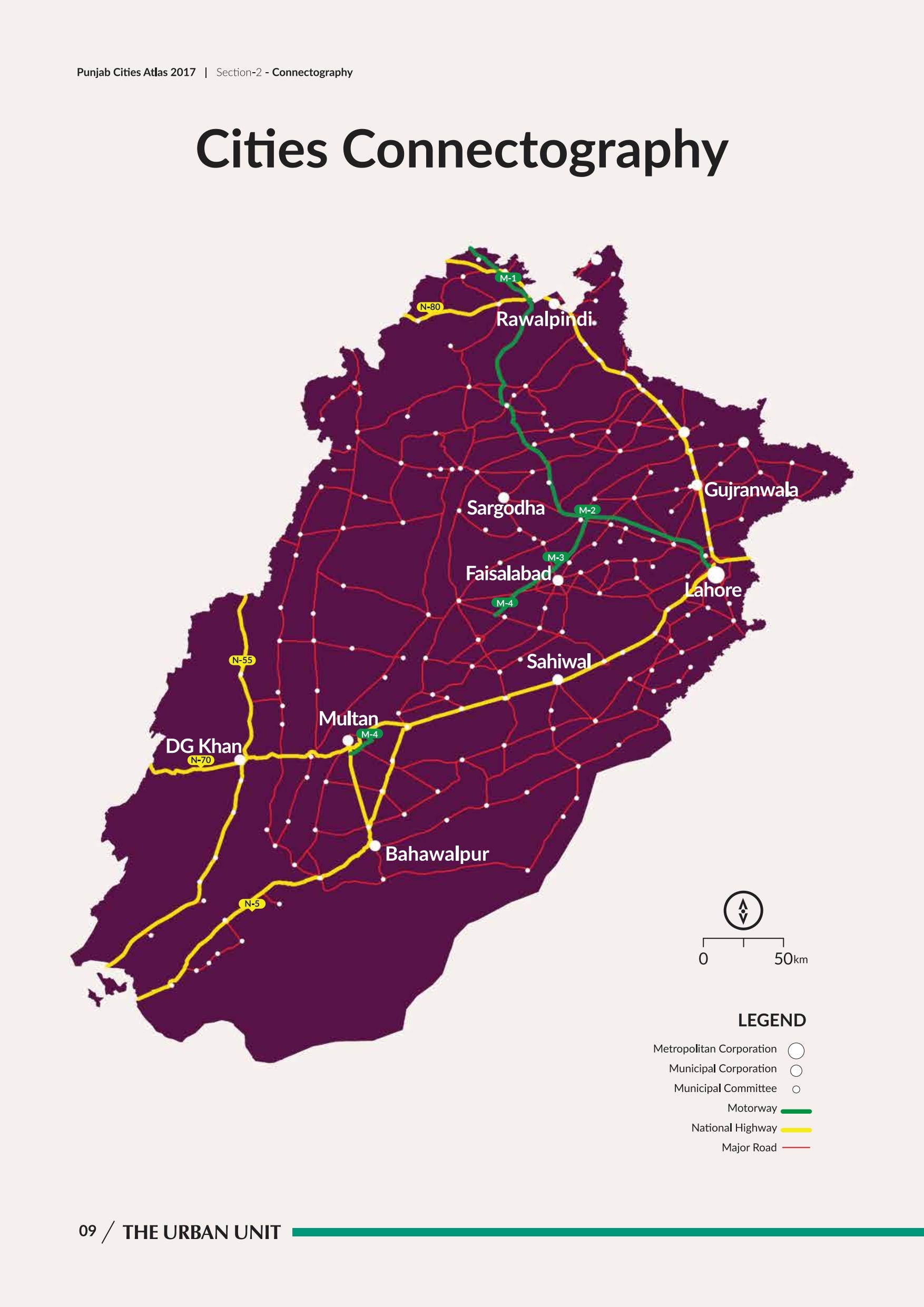

Cities Connectography
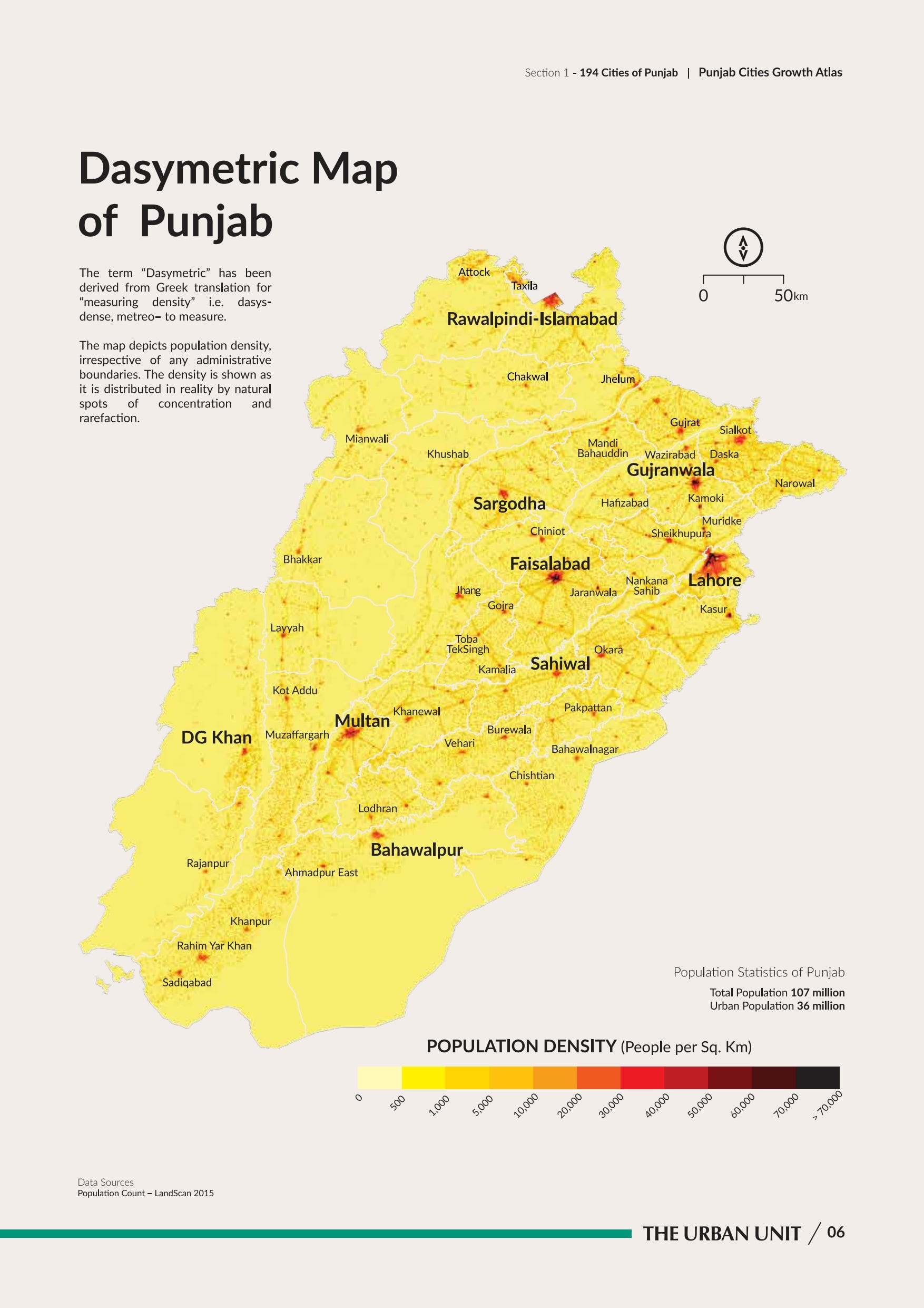

Dasymetric Map of Punjab
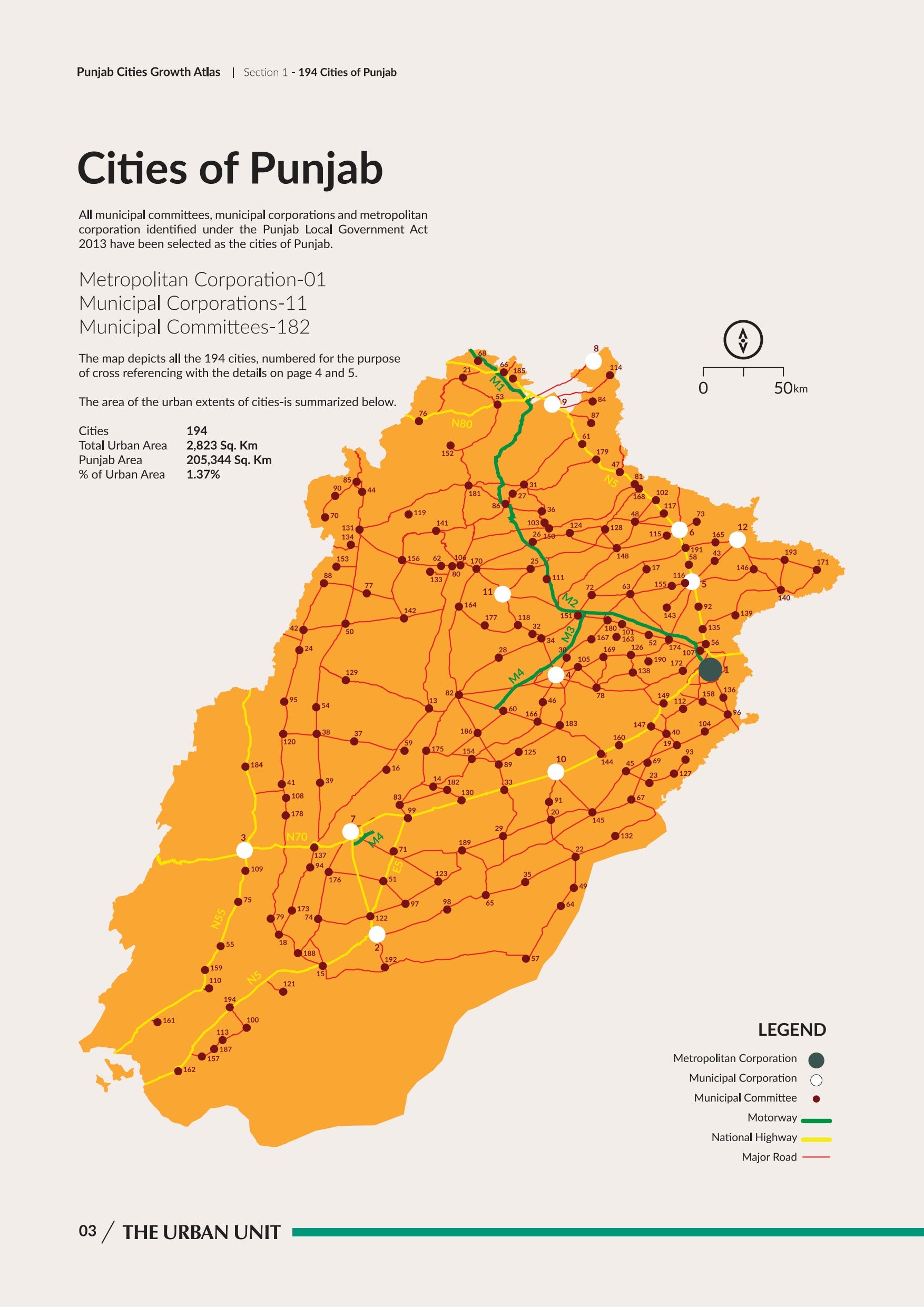

Cities of Punjab

Validation of GOSAT and OCO-2 against In Situ Aircraft Measu
Punjab Cities Growth Atlas 1995-2015
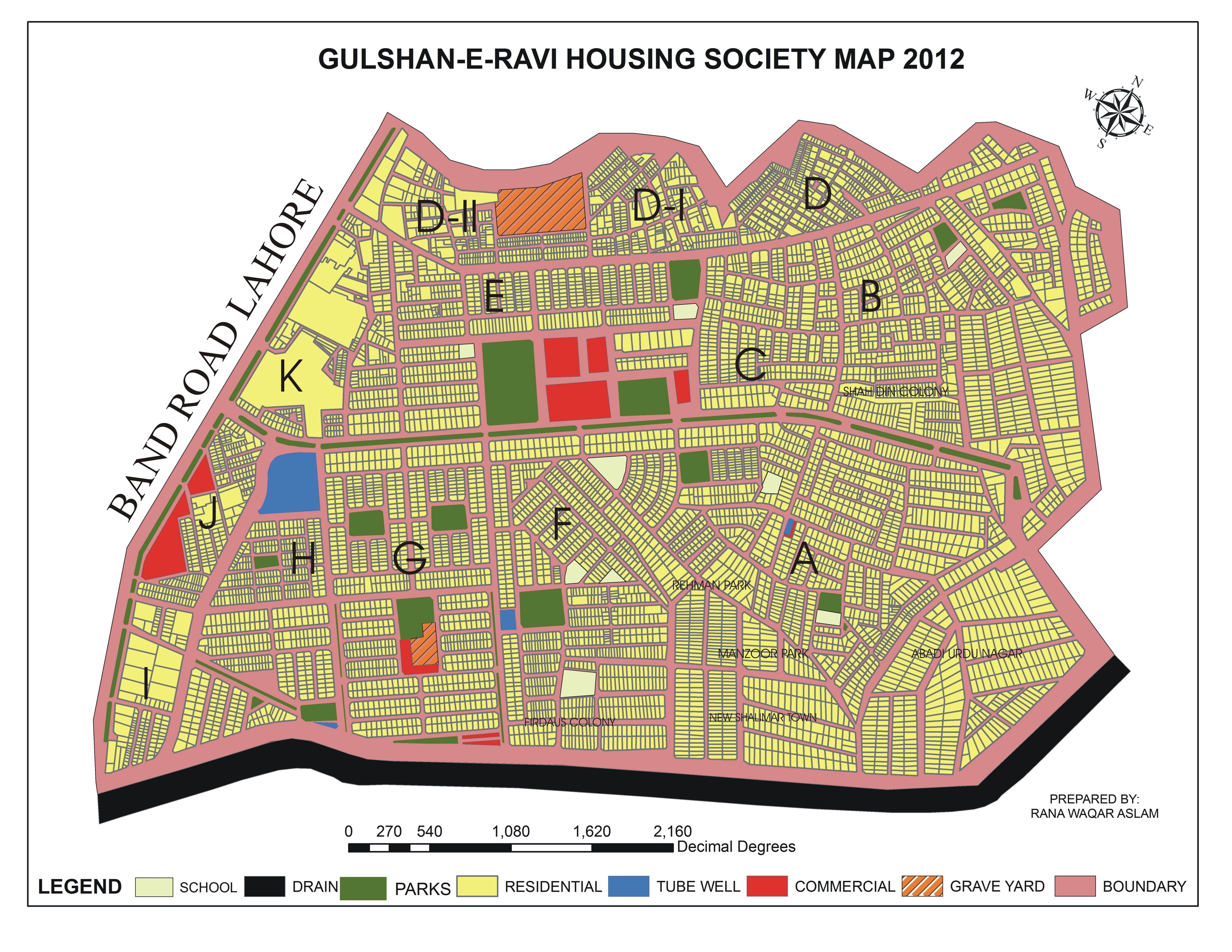

Gulshan-e-Ravi, Lahore.
Cities Connectography
Dasymetric Map of Punjab
Cities of Punjab
Validation of GOSAT and OCO-2 against In Situ Aircraft Measu
Punjab Cities Growth Atlas 1995-2015
Gulshan-e-Ravi, Lahore.
Oceny
Zmiany zapisane
Pokazuje 1 - 4 z 4 komentarzy
$20,00 USD
Engineering
AutoCAD
Google Earth
Geographical Information System (GIS)
AutoCAD Architecture
A
•
$28,00 USD
Data Processing
Excel
Cartography & Maps
Geolocation
Geospatial

•
₹1 000,00 INR
Cartography & Maps
R

•
$56,00 USD
Google Earth
Geospatial
K

•
Doświadczenie
GIS Specialist
sie 2018 - lip 2019 (11 miesięcy, 1 )
Building Address As-Built and Street Signage As-Built: Building and address and street signage with QR code for a self-driving car in Abu Dhabi vision 2020.
• Preparing Maps and Visualize data in presentation mode.
• Quality Assurance of field survey data.
• Designing of maps that describe and interpret findings for the assigned projects.
• Management of databases and maps.
• Ensure the safety and privacy of the data.
• Analysis, interpretation and maintenance of spatial data.
Assistant Manager GIS
paź 2017 - sie 2018 (10 miesięcy, 1 )
• GIS & Remote Sensing Analysis.
• Preparing Maps and Visualize data in presentation mode
• • Quality Assurance of digitization and GIS datasets.
• Designing of maps that describe and interpret findings for the assigned projects.
• Management of databases and maps.
• Mosaicking, Geo-referencing of mosaicked data.
• Ensure the safety and privacy of the data.
• Analysis, interpretation and maintenance of spatial data.
Research Associate (GIS)
cze 2014 - paź 2017 (3 lata, 4 miesiące)
• GIS & Remote Sensing Analysis.
• Preparing Maps and Visualize data in presentation mode
• • Quality Assurance of digitization and GIS datasets.
• Designing of maps that describe and interpret findings for the assigned projects.
• Management of databases and maps.
• Mosaicking, Geo-referencing of mosaicked data.
• Ensure the safety and privacy of the data.
• Analysis, interpretation and maintenance of spatial data.
Edukacja
Photogrammetry and Remote Sensing
(3 lata)
MS/M.Phil
(2 lata)
B.Sc (Hons)
(4 lata)
Kwalifikacje
Network Security
GC University Lahore and Corvit Systems
2011
Disaster Risk Management (Workshop)
NIDM, NDMA, PDMA, UNDP and GCU Lahore.
2012
2-Day Training Workshop on Disaster Risk Management Organized by GC University, Lahore. Supported by (PDMA) (NIDM) (NDMA) (UNDP) 2012.
Publikacje
Land cover change analysis and impacts of deforestation on the climate of District Mansehra, Pak
Journal of Biodiversity and Environmental Sciences
In this study, district Mansehra, Pakistan was chosen as the study area. The main objectives of this research are to assess the extent and the changes in the rate of deforestation in Mansehra since past 20 years. It also examine the impacts of deforestation on the Climate by establishing and mapping the magnitude and rates of land cover changes that had occurred in the study area. Landsat satellite images were taken as secondary data and they were foremost for the classification process.
Critical Study of Groundwater Quality of Metropolitan Lahore Using Geo-Spatial Techniques
International Journal of Sustainable Development
Lahore is famous for its rapid urban growth providing bread and butter to around 11 million population. Availability of clean drinking water to general public is the responsibility of the state. Pakistan ranks at 80 in terms of providing standard drinking water to people. This research is based on monitoring the temporal changes in water quality of various towns of Lahore for the years 2009-2019.
Assessment of Temporal Changes in Landuse Patterns by Incorporating Topographical Parameters
International Journal of Sustainable Development
Urbanization has become a hot issue in context of environmental and socio-political scenarios which is being addressed at every forum internationally. The classification results of Islamabad showed that the total area of Islamabad was about 899.56 sq.km. The area wise percentages of various landuse features remained very diverse in the period from 2000 to 2020.
Hazardous Effluents and their Impacts on Human Health: Future of Industrial Boom
International Journal of Innovations in Engineering and Technology
Industries, being commercial productive units perform as manufacturing agents to produce large quantity of goods to cater the needs of increasing population. Manufacturing units use raw material and goods to deliver the final product. The findings of this research are consistent and reliable.
Validation of GOSAT and OCO-2 against In Situ Aircraft Measurements and Comparison with CarbonTracke
Remote Sensing (MDPI)
Carbon dioxide (CO) is the most important greenhouse gas and several satellites have been launched to monitor the atmospheric CO2 at regional and global scales. Evaluation of the measurements obtained from these satellites against accurate and precise instruments is crucial. In this work, aircraft measurements of CO2 were carried out over Qinhuangdao, China (39.9354 N,119.6005 E), on 14, 16, and 19 March 2019 to validate the Greenhous gases Observing SATellite (GOSAT) and the Orbiting Carbon.
Impure Water, a Future Disaster: A Case Study of Lahore Ground Water Quality with GIS Techniques
19th International Conference on GIS and Geomatics for Disaster Management
This research has been conducted to assess the water quality in and around Lahore Metropolitan area on the basis of three different land uses, i.e. residential, commercial, and industrial land uses. For this, 29 sample sites have been selected on the basis of simple random sampling technique. Samples were collected at the source (WASA tube wells). The criteria for selecting sample sites are to have a maximum concentration of population in the selected land uses.
Road Accident Risk Assessment
Scientific Ravi
For the assessment of Road Accident in Punjab we collect secondary data from Rescue 1122 Punjab Office which provides data from 10/10/2004 to 30/04/2014. This data is registered in Rescue 1122 database and in numerical form. Furthermore they also provide the specific data about 4 wheeler vehicles (and above) and 2 wheeler vehicles. More specifically they also gave us Lahore Towns Road Accident data in tabular form.
Migrant Impact on Gulshan-e-Ravi Infrastructure and Environment Using GIS & Remote Sensing Techniques
G C University, Lahore.
B.Sc (Hons) final year Thesis topic.
GPS Tracking and Its Applications
Scientific Ravi
Annual Scientific Ravi, G C University, Lahore.
Skontaktuj się z Rana Waqar A. w sprawie projektu
Zaloguj się, aby omówić szczegóły na czacie.
Weryfikacje
Najlepsze Umiejętności
Przeglądaj Podobnych Freelancerów
Przeglądaj Podobne Prezentacje
Zaproszenie wysłane pomyślnie!
Dziękujemy! Przesłaliśmy Ci e-mailem link do odebrania darmowego bonusu.
Coś poszło nie tak podczas wysyłania wiadomości e-mail. Proszę spróbować ponownie.
Nie udało się skopiować do schowka. Proszę, spróbować ponownie po dostosowaniu uprawnień.
Skopiowane do schowka.
Wczytywanie podglądu
Udzielono pozwolenia na Geolokalizację.
Twoja sesja logowania wygasła i zostałeś wylogowany. Proszę, zalogować się ponownie.